 |
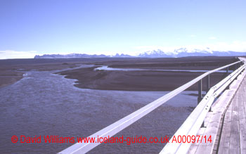
| Skeiðarársandur`s
vast expanse of black sand stretches from the outlet of the glacier
(which is in the distance) to the sea. Skeiðarárjökull
cannot be picked out in this picture as it is a low, gently-sloping
glacier. The high mountains to the right of the picture are covered by the permanent ice-cap of Öræfajökull and to its left is Skaftafell National Park. This wooden bridge carries the country`s ring road over one of the many braided rivers that flow across Skeiðarársandur. These rivers frequently change their course and the volume of water in them can change during the day depending on how much ice is melting. When a jökulhlaup takes place the rivers can wash the bridges away, destroying that part of the road. |
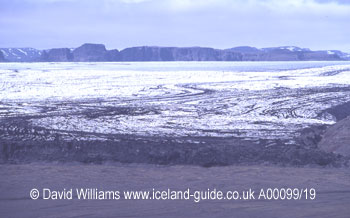 |
| This
is a view over the entire width of Skeiðarárjökull
and it was taken from a hillside within Skaftafell National Park.
The ice becomes blacker towards the front of the glacier. This is because the ice is melting at the front and consequently the ratio of gravel to ice is increasing. The black snout is clearly seen and in front of it is the sandur. |
I awoke early as the hot sun beating down on the tent made it too hot to rest any longer. The sun was already high in the sky and it was time to move on. I bade farewell to the lavafields that Laki had produced two hundred years previously and headed eastwards, towards the vast sandy wasteland of Skeiðarársandur that lay between the Skeiðarárjökull glacier and the sea.
The road surface was as bad as ever. If only I had fixed the Beetle`s suspension in Reykjavík then I wouldn`t have had to endure the thumps that shuddered through the car every time I hit a pothole.
After crossing the first section of the black sands, the glaciers came into view. I had to stop and pinch myself - was this real? Blue sky, white clouds, black sand and white glaciers - and all the shapes and colours reflected in the moss-fringed pools of water dotted across the landscape. The cameras were kept busy - I was anxious not to miss the moment.
Time to explore. I left the car beside a long wooden bridge that spanned the braided glacial rivers and walked across the sandur towards the glacier. To left and right were kettle holes, deep circular depressions ten to twenty metres across; these marked the last resting places of icebergs which had been stranded and had slowly melted.
I noticed a little wooden hut on the bare sand and peeked in. It was presumably an observation post used by scientists.